Taj Mahal was built by a grief stricken Emperor Shahjahan as a memorial to his beloved wife Mumtaz Mahal. A world-renowned wonder, Taj Mahal sits pretty on the northern side of this green paradise. It looks the same from all the four sides! The Quranic inscriptions on its four entrances are carved in such subtle increase in size that may appear to be of the same size from top to bottom! Shahjahan invited master craftsmen from as far as Italy and Persia to help design his ambitious tribute to love.
The Taj Mahal is phenomenal not in the beauty alone that shines forth, but in the deep planning and design that went into its making, and the ethereal idea of immortalizing love. Delicate carvings in marble vie with gorgeous pietra dura for attention. Lapis-lazuli, Cornelian, Mother of pearl, Agate and Emerald are inlayed in floral and geometrical patterns in the marble itself. This enchanting mausoleum, on the bank of river Yamuna started in 1631 and it took 22 years to complete with the help of an estimated 20000 workers.
 |
| Taj Mahal |
The Agra Fort The great Mughal Emperor Akbar commissioned the construction of the Agra Fort in 1666, A.D. although additions were made till the time of his grandson Shahjahan.The forbidding exteriors of this fort hide an inner paradise. There are a number of exquisite buildings like Moti Masjid - a white marble mosque akin to a perfect pearl; Diwan-I-Am, Diwan-I-Khaas, Musamman Burj - where Shahjahan died in 1666 A.D. Jahangir's Palace; Khaas Mahal and Shish Mahal.
Jama Masjid
Jama Masjid
The building with rectangular open forecourt was constructed in 1648A.D. by Shahajahan's daughter, Jehanara Begum. Of particular importance is its wonderful assimilation of Iranian architecture.
 |
| Jama Masjid |
Red Fort
The Red Fort (usually transcribed into English as Lal Qil'ah or Lal Qila) is a 17th-century fort complex constructed by the Mughal emperor, Shah Jahan in the walled city of Old Delhi (in present Delhi) that served as the residence of the Mughal Emperors and the fort was the palace for Mughal Emperor Shah Jahan's new capital, Shahjahanabad, the seventh city in the Delhi site. He moved his capital here from Agra in a move designed to bring prestige to his reign, and to provide ample opportunity to apply his ambitious building schemes and interests. It served as the capital of the Mughals until 1857, when Mughal emperor Bahadur Shah Zafar was exiled by the British Indian government.
 |
| Fahpur Sikri Palace |
The fort lies along the Yamuna River, which fed the moats that surround most of the walls.The wall at its north-eastern corner is adjacent to an older fort, the Salimgarh Fort, a defence built by Islam Shah Suri in 1546. The construction of the Red Fort began in 1638 and was completed by 1648. The Red Fort has had many developments added on after its construction by Emperor Shah Jahan. The significant phases of development were under Aurangzeb and later under later Mughal rulers. It was designated UNESCO World Heritage Site in 2007. The earlier Red Fort was built by Tomara king Anangpala, now it is known as the Qulb Mosque.
 |
| Golconda |
Golkonda
Golkonda also known as Golla konda (shepherd's hill) a ruined city of south India and capital of ancient Kingdom of Golkonda (c.1518–1687), is situated 11 km west of Hyderabad. It is also a mandal of Hyderabad District. The region is universally famous for the mines that have produced the world's most famous and coveted gems, including The Hope Diamond, Idol's Eye, The Koh-i-Noor and Darya-i-Noor.
The most important builder of Golkonda was Ibrahim Quli Qutub Shah Wali, the fourth Qutub king of the Qutub Shahi Dynasty. Ibrahim was following in the spirit of his ancestors, the Qutub Shahi kings, a great family of builders who had ruled the kingdom of Golkonda from 1512. Their first capital, the fortress citadel of Golkonda, was rebuilt for defense from invading Mughals from the north. They laid out Golkonda's splendid monuments, now in ruins, and designed a perfect acoustical system by which a hand clap sounded at the fort's main gates, the grand portico, was heard at the top of the citadel, situated on a 300-foot (91 m)-high granite hill. This is one of the fascinating features of the fort.
They ruled over most of present day Andhra Pradesh before the British Raj. After transferring Northern Circars to British, they ruled the Telangana region and some parts of present day Karnataka and Maharashtra.
Jhansi Jhansi Urdu is a historic city of northern India, located on the banks of the Pahuj or Pushpavati River, in the state of Uttar Pradesh. It is located in the region of Bundelkhand. Jhansi is the administrative headquarters of Jhansi District and Jhansi Division. The original walled city grew up around its stone fort, which crowns a neighboring rock. This district is on the banks of the Betwa River.
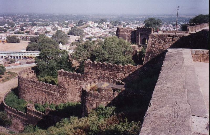 |
| Jhansi Fort India |
The city is situated between the rivers Pahuj and Betwa between North longitudes 24°11´ and 25°57´and East latitudes 78°10´and 79°25´. It has an average elevation of 284 metres or 935 feet. The boundary of the city is irregular, the northern boundary being contiguous with that of the district of Jalaun. Jhansi is well connected to all other major towns in Uttar Pradesh by road and railway networks. It is about 415 km from New Delhi and 292 km from Lucknow, and it is called the Gateway to Bundelkhand.The National Highway Development Project has supported development of Jhansi. The north-south corridor connecting Kashmir to Kanyakumari passes through Jhansi as does the East-West corridor; consequently there has been a sudden rush to infrastructure and real estate development in the city. A greenfield airport development has been planned.
No comments:
Post a Comment